Last week, a powerful tornado in the state of Mississippi claimed numerous lives and caused major destruction in several small towns. Traditionally, however, the tornado season is just beginning at the end of March. There are indications that the early tornado season will be more active in the medium term. Already today, there are the next thunderstorms with a large tornado potential.
Deadly tornado last Friday
Exactly one week ago, a powerful tornado moved from Louisiana to Mississippi, striking the small towns of Rolling Fork, Silver City and Winona, among others, in its more than 150-kilometer path. At least 26 people lost their lives as a result. A preliminary assessment by the National Weather Service rated that tornado as EF-4 (EF-0 to EF-5, with EF-5 corresponding to the highest level) on the Enhanced Fujita Scale, which corresponds to wind peaks of about 300 kilometers per hour.
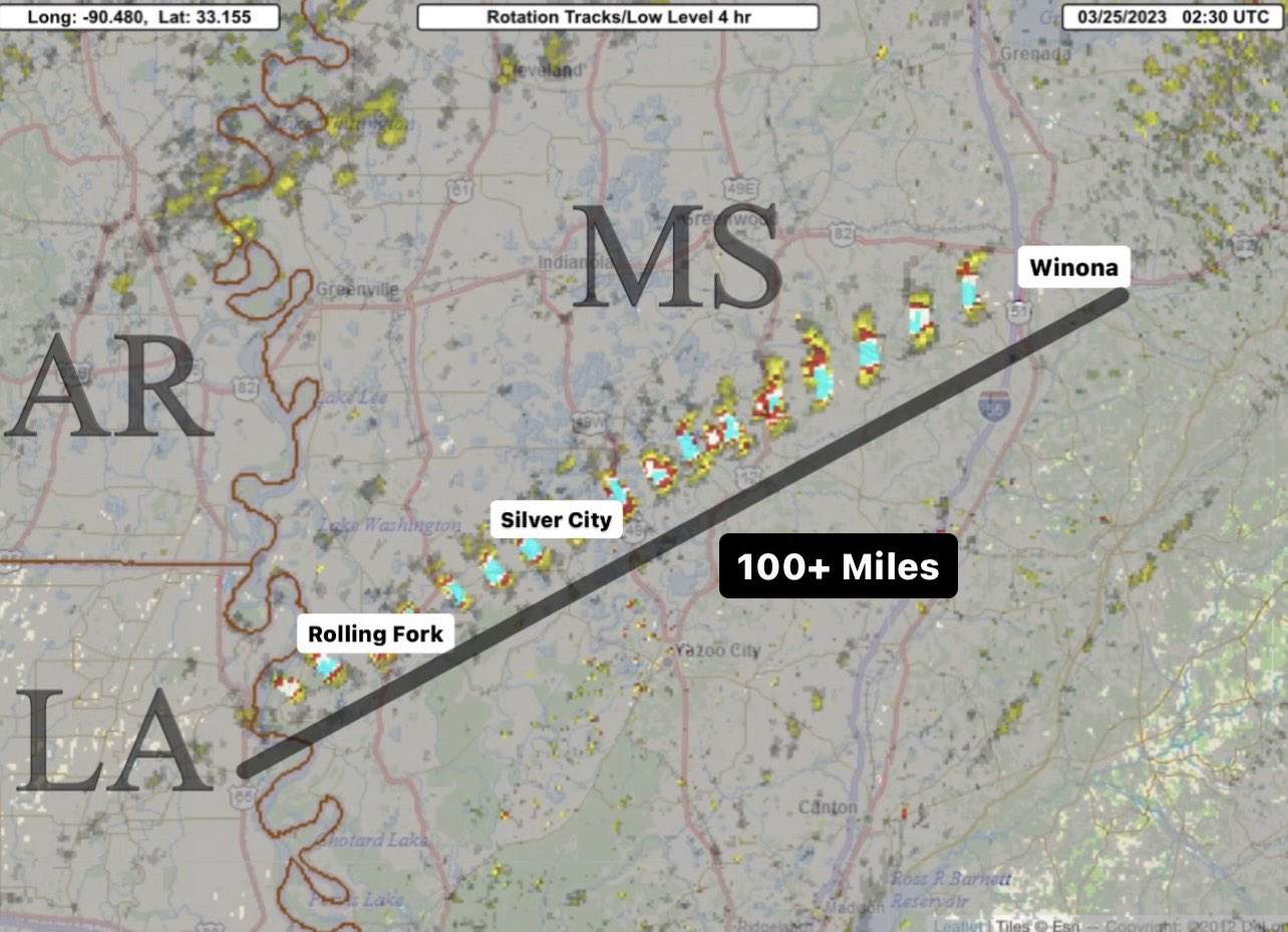
Fig. 1: Train path of last week's strong tornado; Source: Collin Gross
The average tornado season
In principle, tornadoes can form in the United States in all months. Due to the lower temperature level and the lower irradiation, but also due to lower moisture content of the atmosphere and its often more stable stratification, tornadoes are rather rare in the winter months. Between December and February, an average of between 80 and 100 tornadoes are counted nationwide. This figure rises markedly in the spring and peaks in early summer. The reason for this lies in the competing air masses, which are separated by the jet stream. On its southern side, warm and humid air masses flow northward from the Gulf of Mexico, while on the northern side there is cold and mostly dry air of Arctic origin. When these two air masses meet, the cold and denser air is pushed under the warm Gulf air. The lifting causes condensation and thus the formation of clouds and later also thunderstorm cells. Since these air currents come from different directions, this leads to a change in direction of the wind with height when they meet – the basis for so-called supercell thunderstorms is created. In about 30% of the cases, a supercell subsequently also produces tornadoes. This process is well illustrated in the following graphic. More information on the formation of tornadoes can be found in this blog, among others.
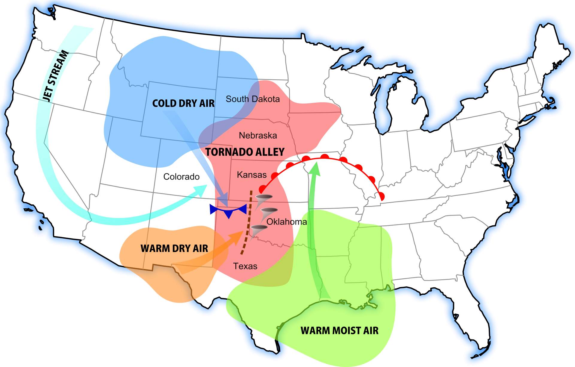
Fig. 2: Typical setup for tornadoes; Source: Dan Craggs
The actual tornado season spans the months of April through July, with regions affected to varying degrees depending on the month. Typically, the first tornadoes form first in the somewhat lesser known Dixie Alley. Roughly speaking, this region includes the Gulf States east of Texas, from Louisiana to Georgia. From May through July, the focus increasingly shifts to the Midwest. From Texas to North Dakota and east to Illinois. This region is well known as Tornado Alley. On average, about 1200 tornadoes form in the U.S. each year, half of them in May through June.
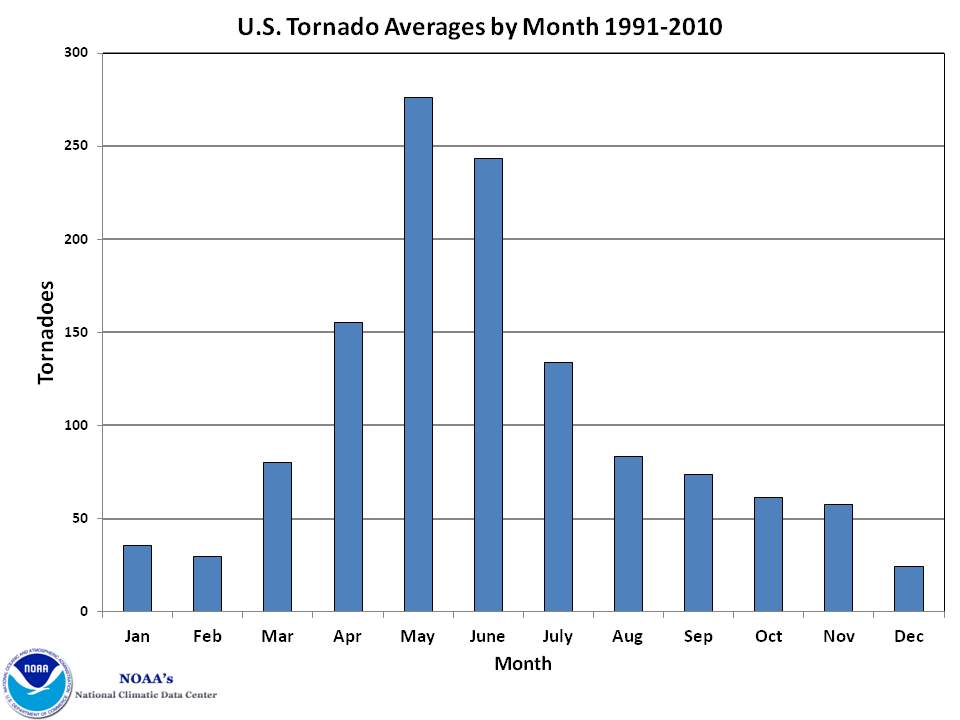
Fig. 3: Tornado frequency by month; Source: NOAA
Next outbreak imminent
For today, the National Weather Service's Storm Prediction Center sees an increased severe weather potential for about 70 million residents. On the one hand, the border region between Iowa, Missouri and Illinois is particularly in focus; on the other hand, severe storms are also expected for the region from western Arkansas to Tennessee. Gale-force winds and several tornadoes are expected, some of which will be strong and long-lived.
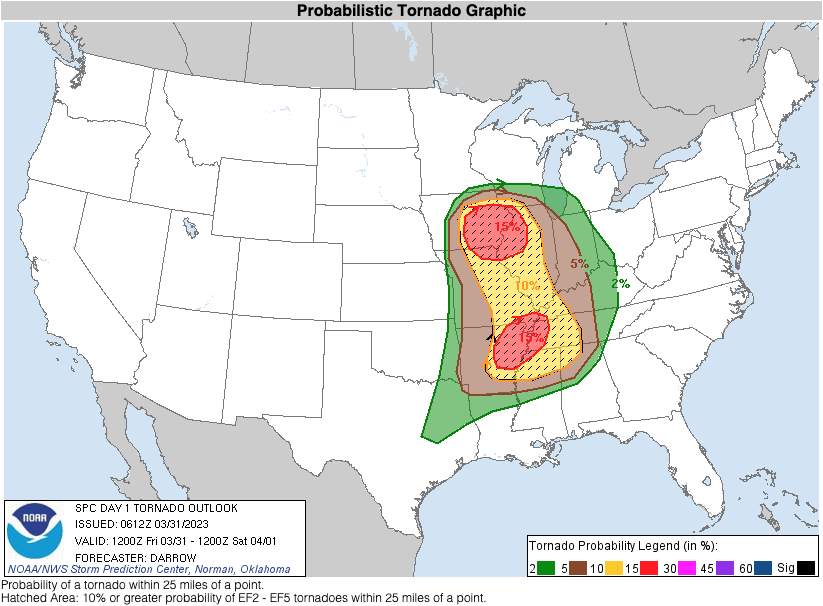
Fig. 4: Today's tornado threat; Source: NOAA
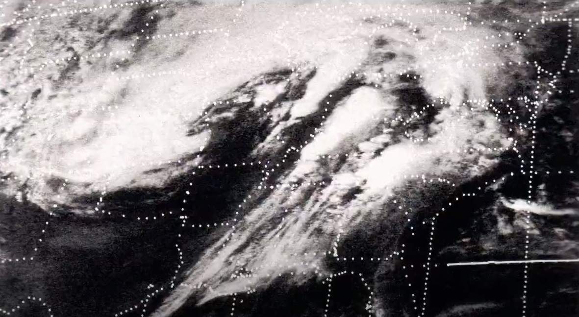
A weather constellation similar to what we have today resulted in a tornado outbreak in that region in December 2021. At that time, the Mayfield tornado alone took the lives of more than 50 people and injured more than 500 others. Over a two-day period, a total of 71 tornadoes formed at that time.
Active early season
As official figures show, there have already been 310 tornado reports this year through March 29, about 100 more than normal. This year's January, along with those of 1999 and 2017, is one of the top three since detailed records began in 1950, and February was topped by only a few years (1999, 2008, and 2017).
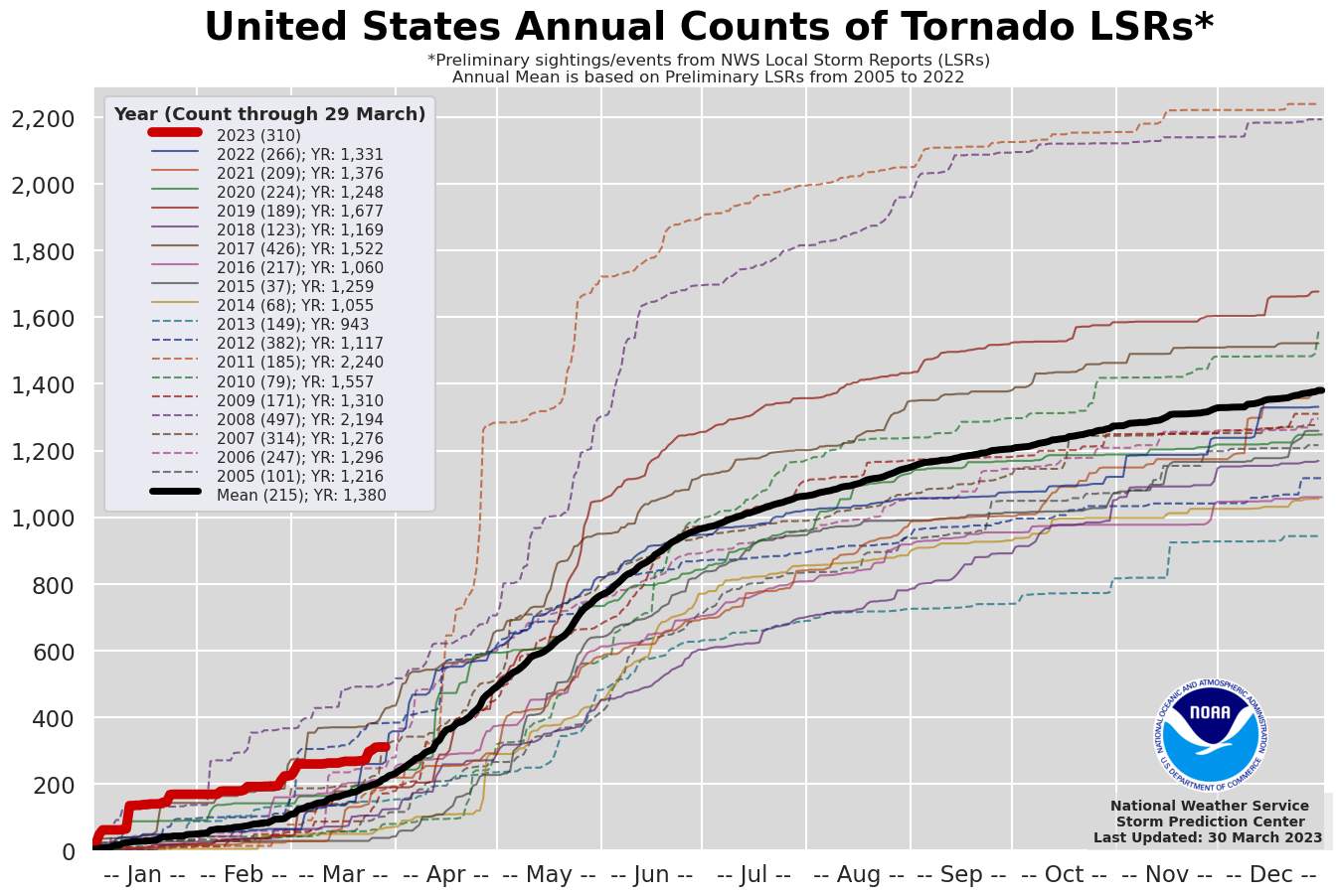
Fig. 5: Number of tornado reports for the year to date compared to previous years; Source: NOAA
Continued high tornado activity
According to medium-range forecasts, high tornado activity will not change anytime soon. North America is currently in a pattern of high amplitude storm systems moving across the continent from the Pacific Ocean at regular intervals, increasing the risk of severe weather. According to experts, such a pattern can only be observed every ten years or so. It is therefore not surprising that the next major storm threat in the similar region is already forecast for next Tuesday.
disclaimer
The content of this article has been at least partially computer translated from another language. Therefore, grammatical errors or inaccuracies are possible. Please note that the original language version of the article should be considered authoritative.


